Wednesday, February 28, 2007

bubbles, part 2

Yesterday I wrote a little about why we're collecting water samples
(for dissolved gases) and I promised to tell more about the sampling
techniques. They are a weird blend of extreme delicacy and brute
force. As a "modeler" I have a tendency to gloss over the detailed
methods used to obtain oceanographic data -- there is a measure of
trust that the techniques work and that the data is accurate. After
all, these are "observations" of the real ocean, rather than output
from a computer. On top of this, the details of the sampling
techniques -- I mean the nitty gritty -- are not necessarily relayed
in papers.

The concentrations of the gases we are looking at are extremely
small, which has two effects. First, the sensitive equipment
required to analyze the samples is not practical to have on board --
so we have to collect water and send it back to the lab (hence the
water-catcher moniker). Second, we have to be extremely careful not
to compromise or change the sample, or contaminate it with gases that
were not in the water when it arrived on board. So knowing that,
here are the two techniques which I have spent considerable time
perfecting over the past month, in two installments.

For "noble gases" -- including two isotopes of helium, and neon -- we
use helium channels, which I discussed earlier, because we assembled
a few hundred in the first few days on board. Anyway, these consists
of a hollow aluminum rectangular "channel", about three feet long,
with steel clamps on each end, and a copper tube in the middle with
its ends sticking out between the clamps. When the CTD (and attached
rosette of 24 10 liter bottles) arrives, I attach plastic tubing to
both ends of the copper tube, find the bottles which I'm sampling
(each of which has been triggered at a specific depth) and attach one
end of the tubing to the valve at the base of each bottle. I test
the bottle to make sure it doesn't leak, then open the vent at the
top of the bottle. Pushing in the valve again starts the flow of
water. At this point I let water run through the tubing, the copper
tube, and out onto the floor through the plastic tube on the other
side, keeping the channel tipped up away from the bottle so air in
the tubing and channel can escape. Then I flip the channel over (so
copper tube and clamps are facing away from me), place the channel on
my thigh, and bang the channel for about 20 seconds with a mallet to
knock the bubbles out (which stick to the copper). Then I flip the
channel back over (keeping it upright), grab a pneumatic impact
wrench, center the copper tube in the channel, and drill the two
bolts on each clamp down so the clamps stop the flow of water in a
hurry (For those of you, who, like me a month ago, did not know whan
a pneumatic impact wrench is, it's what the use in auto repair shops
to bolt on hubcaps). It's like an indy-car pit stop. And it makes a
complete racket. And I get to do it 5 or 6 times at every station
(we've done close to 100 so far). How this method was developed, I
have no idea. But many people have thought about this and on a ship
in the middle of the Antarctic this is the best way to seal in the
few parts per billion that are the difference between water types.
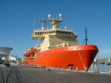
Tuesday, February 27, 2007

bubbles rule!

For some reason, non-scientists seem to get very excited about ice
cores. And they should! Cores provide the best record of climate
changes over the past half million or so years. Not to mention it's
pretty cool to drill 4 km into a block of ice.

What I'm doing on this cruise is basically the same thing, only we're
using water in a different form. Ice traps air as it is compressed
from above by accumulating snow. Seawater exchanges gas with the
atmosphere only when it is on the surface of the ocean. Over time,
ice is squeezed into thinner and thinner layers, and removing a
vertical column of ice can reveal concentrations of gases (and
isotopes of gases) which provide a record of almost anything climate
related (temperature, precipitation, both local and globally
averaged), and a snapshot of the composition of the atmosphere when
the ice was buried (technically after all of the pores close off).
In the ocean, it's a little more complicated -- once water sinks,
it's very hard to keep it in the same place (but remember ice moves
around too), and it mixes with water around it (but not much!). But
ocean tracers (as all of these gases are known) can provide almost
the same information than ice cores -- and are especially important
over the timescales associated with water sinking to depth and rising
to the surface -- hundreds to thousands of years. Dissolved gases
provide not only information about their source regions, and when and
where the water sank, but also can help us learn how much the water
which we sample has mixed along the way to it's eventual sampling
container aboard the NBP.

The preceding diversion (which I hope you made it through without
closing the page) is really a lead in to the main activity today --
sea ice coring! My partner in water-catching (as our leader
describes our activity) is interested in the transport of the gases
we're analyzing through sea-ice (or just needed an elaborate ruse to
get off the ship after a month). So we are trying to use a similar
sampling method to what were using for some of the dissolved gases to
look at the concentrations in ice -- which reminds me I really need
to describe the sampling (which involves power tools and immersion in
-2 degree water) soon, but not today. Along with a group who was
deploying an automated weather station, we were lowered to an ice
floe on an innertube with a rope ladder attached to it (like a
teepee). Then we took our own core of snow and ice -- about 30-40 cm
of snow and about 2m of sea ice. The weather timing was poor,
horizontal snow and no visual differentiation of snow and sky, about
-10 degrees, but it was worth it to get out on the ice again. Whether
the technique will work is unknown, but it was a nice break in the
schedule, which, a month into the cruise, is not exactly full of
surprises.

And thanks to Kate, a visitor whose email has inspired me to get back
into the science a little.

C

Sunday, February 25, 2007

Daylight savings?

We've had a few tough days of sampling near Pine Island glacier (as
close as we can get anyway) and I am tired. Blog entries are
suffering a little as a result. I'm also having trouble finding time
to do the analysis of some of the nutrients and other measurements,
as well as think about my own work and how I'd like to tie it to this
region and this data. I'm trying to think about this a) because I
need to think past the next month and 2) also because I'm planning to
give a "science talk" on the cruise at some point. Modeling (what I
do usually) and observations (which I'm currently gathering) are both
vital and can be symbiotic when the other side is involved in framing
the experiment and involved in the analysis. I thought I'd try to
address some of the key capabilities models offer, then try to
stimulate discussion of how to use either this cruise, or general
observational data in the region, for better modeling studies. But
I'd like to be more specific.

Our PI on this cruise often turns a question like "where are we going
next?" into "where do YOU think we should go?" -- which is great if
you have a firm grasp of your own objectives. But I've been trying
to assimilate the mass of data we've been collecting, and my ideas
for what questions are important (and answerable) are still up in the
air and may be changing. Luckily I still have a month or so to
think, and luckily others on this ship are stuck within 360 feet of
me, so they'll be forced to listen as I babble.

The sampling, hands-on lab work, and power tools are a great way to
break from these questions, but at this point they're a 12 hour a day
job. Not enough hours in a day (even one with 22 hours of daylight)
to get it all done.

For those who've sent email, thanks! I'll get back to you soon.

And Happy Birthday Mom!

C

Friday, February 23, 2007

Leading the way

Over the past few days, winds have shifted to the south and east.
This has blown open a lead into Pine Island Bay which has not been
there since the start of the cruise. As I write, we're about to
enter the lead, which cuts between thick sea ice and fast (i.e. stuck
to the land and not going anywhere quickly) ice. I will probably be
asleep and not around to see if we make it, but chances look good if
you believe the satellite pictures from the past few days. This is
either a coup or an sneaky trick by the gods of weather and ice. It
is possible that the opening closes while we're in there, and that
our other ambitions outside the immediate region of Pine Island
glacier are hindered. Worst case scenario, we're stuck for a while.
I think we have enough desserts to make it through the winter though,
so don't worry about me.

We got a little preview of the oceanographic conditions in some
troughs which we sampled on the way over to PIB today. Basically
everywhere below 500-600 m is around 1.2 degrees C. Cold (still
freezes my hands when sampling), but way warmer than necessary to
melt ice. Our big questions are: where does this water go near the
ice shelves, how does it get there, and what drives it and the flow
of any meltwater which forms when it hits the ice. The CTD casts and
samples we'll get will provide clues which we'll put together as they
are analyzed. It's a frustrating part of this experience that we
can't know more about what we've collected earlier, but such is the
speed of progress (and observational science).

Thursday, February 22, 2007

Lachat, part deux

In the 3 (?) weeks on the ship so far, I've grown more confident in
my lab chemistry skills, which were dormant for many years. Maybe
every two days or so, I make standard samples, calibrate the machine,
and analyze water samples which we've taken from CTD stations and the
sea surface. I shouldn't say I, I still am getting a tremendous
amount of help and guidance from Bettina, the MST who's responsible
for nutrient analysis and responsible for the Lachat "bible". Anyway,
today I broke the Lachat at 6 am and it got angry and decided to shut
down twice spontaneously after she fixed it for me.

A little background on the Lachat -- we make samples with a varying
known concentrations of phosphate nitrate ammonia nitrite and
silicate, then the machine measures their absorption of light of a
specific wavelength at each concentration, then the water samples are
measured and compared with the calibrations in order to arrive at a
concentration in the samples. Anyway, the nitrate "channel" uses a
column filled with cadmium to convert all of the nitrate to nitrite
so it can be measured. If air gets in the column, it is, in the
words of the "bible", "toast". I have been reminded many a time not
to do this. One of the dumber ways to let air in the column is to not
put a sample in a location where the "autosampler" samples. Today,
I did not put a sample in place. The column was toasted.

Then the winch responsible for holding the CTD had some mechanical
difficulties and needed about a 6 hour break. Which wasn't all that
bad because we had a major nutrient backlog.

I have blamed these problems and others on the evil gnome running
around the ship. Hopefully he's had enough fun. Things seem to be
calming down, the nutrients are analyzed, we're headed for our next
station, and I'm going to go to sleep without messing around with
anything mechanical.

Word is the sun is going down for about two hours a night now.
Springtime in the northern hemisphere yet?

Sunday, February 18, 2007

following the ice edge

a slight diversion on a related topic...

sea ice, which if you'll remember is good for wildlife, is tough on
oceanographers. one of our main goals on this cruise is to take
thorough measurements in the ocean in and around Pine Island Bay,
tucked into a corner of the Amundsen Sea which is perennially blocked
by sea ice. ironically, the reason why we want to take measurements
in the region is because the melt rates under glaciers which
terminate in the Bay are orders of magnitude higher than anywhere
else in Antarctica. But that's caused by water at depth -- unrelated
to the surface ice condition.

we can learn about the circulation from outside the Bay, but it would
be ideal if we could do it all. in some years it's possible to break
through the ice to get into the open interior of the bay; cruises in
many years have been thwarted. this will be a topic of much
discussion and anxiety over the next few weeks -- i'll keep you
posted. anyway we will still be in and around the ice edge so i will
continue to relay wildlife encounters regardless of our success in
getting to all of our stations. my personal tally in 2 visits outside
yesterday, 4 orcas, a dozen or so crabeater seals, a few emperors.

in the meantime, we're working our way in, taking CTD's from the
continental shelf break, trying to follow the "warm" water in towards
shore, currently at 72.7 S, 121 W.

C

Friday, February 16, 2007

A request for a new series; overview and part one...

We're "transiting" (aka steaming) to our next stop on this cruise
today and tomorrow -- the Amundsen Sea. I think in total it will be
almost a 48-hour run to get to our next series of stations, so it's a
good opportunity to get caught up with sleep, reading, work, and the
blog.

Most of what we've done up to this point has been a little
opportunistic, and the main thrust of the work will be done in the
next few weeks. It takes so much effort and planning to get the
material, people, etc. for a cruise like this that it makes sense to
acquire as much data as possible along the way. Since the Ross Ice
shelf is on the way to the Amundsen, we used the chance to take a
series of measurements which will extend the time series of data and
can help examine long term trends in currents and temperature. We
also took a stab at making some new measurements in depressions in
the continental shelf to the east of the Ross Sea, but had to work
hard to find these troughs (because the bathymetry is poorly known)
and get to them (because the sea ice is/was thick). In the Amundsen,
because of the distance and inaccessibility (primarily due to the
year-round sea-ice) there is nowhere near the amount of data
available, and this cruise will be one of the few data points
available to understand the oceanography of the region. If you're
wondering why we're going here and why it's important to my research,
there's a page on my website -- www.princeton.edu/~cmlittle.

I'm
sure I'll get into some more details at some point when i run out of
ideas for new topics...

But I'm not there yet, thanks to some help from my audience. I have
received a few suggestions, all of which mentioned Antarctic
wildlife. And it's true I've only mentioned it in passing, so I'll
make an effort.

It's lucky that I'm on a cruise around the coast, because both the
continent and the open ocean are really poor places for wildlife
viewing. But in between these extremes, the sea ice and the coast
are spectacular. In summer, the melt-back of the sea ice, the high
nutrient concentrations (!), and the 24-hour daylight are terrific
for anything that can tolerate the -2 degree water. What are the
most exciting are of course the penguins and the marine mammals
(although the krill are pretty cute too). So in my next series of
entries I'm going to try to write about these guys:

First, I'll mention the most common sighting: Adelie penguins (2-2.5
feet tall, stereotypical black and white penguins). In the ice,
they're usually hanging around somewhere within view of the ship. I
have asked around about whether they have a tendency to travel in
groups of specific sizes, but my observations and the advice I've
gotten from the more seasoned aboard the NBP indicate that there is
no pattern. Sometimes you'll see them alone on a solitary floe in
the middle of nowhere, and sometimes they'll be tens of them all
crowded around a ridge on the ice trying to gain a better position.
They look incredibly goofy -- they're usually running away from the
ship, which is crashing through the ice, and they are never able to
decide whether it's easier to walk or slide on their bellies. They
are funny either way -- when they're sliding, they use their front
arms (wings, flippers?) to swim through the snow, when they're
walking, they hold their arms out to the side waving them around and
they move sideways almost as much as they move forward. Underwater,
they're supposed to be graceful and elegant, but unfortunately for
them, I never get to see it.

This is a topic which really deserves pictures, which is impossible
under my bandwidth-limitations -- this may be why I've avoided
talking in detail about our encounters. I do have a ton of pictures
-- personal and taken by others with much bigger lenses, and you'll
just have to wait till I can illustrate these words. It'll be worth
the wait.

C

ps nate I'm at lat 72.8S, lon 138W.

Thursday, February 15, 2007

2 week survey

Hi everyone, whoever you are. I'm finding this form of communication
(blogging) a little one-sided. I'm wondering what you're thinking.
So here's a proposal.

I am severely limited on my email (25k/day) on board, but I have a
little room for extra right now and was hoping you could let me know
what questions you have or anything you want to hear me ramble about
-- i.e. special series a la life on the NBP. If you want, please let
me know at chris.little@nbp.usap.gov. Keep it short (and no
attachments!), and please don't give it out to spammers or mailing
lists. It will help the blog. And will be great to hear from you!

Thanks -- C

Wednesday, February 14, 2007

part 3 in our series, work/life balance

I've mentioned before that the work on the NBP continues 24 hours a
day. When you reach a station, there have to be enough people awake
and functioning to run all the equipment. So early in the cruise, we
broke up into 2 person teams with pre-determined responsibilities.
The crew and the technical team also run on a shift schedule. The
standard shift is 12 to 12. I'm working on a 3 to 3 schedule because
we (Brice, my roommate and partner in tracers/nutrient work) wanted
to see and work with other people. It's working out OK for me. Like
we thought, it's a bonus to work with other people. Unfortunately
(and I may have already mentioned this) the 3 to 3 shift doesn't
match with the meal schedule so well. And I've been really tired at
1-2 pm, but I don't want to sleep that early because I've been trying
to stay up for dinner. But then I'm not able to fall asleep after
dinner. So I'm trying something new and maybe counterintuitive this
Valentine's day, waking up earlier (or is it later?), eating midrats,
and then trying to sleep right after my shift -- forget dinner, who
needs it!

Just because you're "on watch" doesn't mean your constantly working.
Even on a transect, the CTD stations are spaced out so you have a
short break to organize in between. Since I'm analyzing nutrients
(or nuts, pronounced noots) I need long breaks (3-4 hours) to set up
and run the equipment. Over the past 3 days or so (after the RIS
transect), we've had ample time because of the space between stations
and the thick, thick sea ice. In fact, I don't think we've had a
station in 48 hours. Such is life on the NBP -- hurry up and wait.

When you're done with the shift, you're free to go wherever and do
whatever you want within a 360 foot radius of where you work.
Possibilities include the diversions I mentioned in Part 2, blogging,
watching wildlife (the sea ice has been terrific for wildlife --
emperor and adelie penguins, minkes, and a Ross seal (rare)--
watching), science talks (more later) or catching up on non-cruise
related work. I've stayed away from the lounge, but there are a ton
of movies worth watching in there. I'm finding there's not enough
time to take advantage of the off-hours and that I'm spending more
time looking at the cruise data after the watch. It's like reading
encyclopedias or looking at road maps or the weather channel, there's
always a new piece of information to distract you. Anyway, enough
philosophizing, time for my inagural midrats!

Happy Valentine's everyone!

C

Sunday, February 11, 2007

NBP life part 2 - modern conveniences, or, did I really need to bring 40 pounds of ECW?

I've alluded to some of the comforts that the ship affords us. It's
not home, but it's not roughing it in any way. Although we're
exploring some of the most remote areas on the planet, we're doing it
with little of the original adventure (and danger) of the continent's
more famous explorers. Maybe it's not quite the same experience, but
I doubt we'll have to resort to eating penguins and/or our shoes.

Here are a few of the luxuries in addition to the food (update:
chicken cordon bleu for lunch today):

The ride is smooth. I've heard that ice-breaking ships can roll more
in heavy seas, because some of them have a rounded bow. But even in
the storm we went through, the picture out the window looks a lot
more severe than the ride inside the NBP. Especially aft, where most
of the labs are.

Laundry is right down the hall next to the:

Gym -- which is much bigger than I'd been led to believe, adequate
for a small hotel. You've never exercised until riding a stationary
bike in a room with no windows on a ship in a storm. After the gym
you can head to the:

Sauna, with its own changing room and steam-capability.

There is an ample library and a VHS and DVD collection. I found the
TV has an alarm feature, so I can wake up to a movie at 2:30 in the
morning. I would wake up to winch TV except that it very rarely has
any sound.

There is a huge computer server and any scientific software we might
need unless it's really obscure. The labs, especially on a small
cruise, have plenty of space -- I work in the aft dry lab with one or
two other people when I'm working on collecting and managing samples
and by myself in the hydro lab when analyzing nutrients. Which is
cool because they have speakers installed and the nutrient work
demands tunes.

I never have to go outside and it's comfortable almost everywhere on
the ship, so answer to the question in the title is no. The only
thing I've needed is the standard USAP red parka for photo excursions
to the bow. What can I say, life is good.

NBP life, part 1

Encouraged by discussions with shipmates and family, I'm starting a
series on NBP life today. The inaugural entry concerns possibly the
most important aspect of any day -- food!

Four meals are served in the galley each day, similar to the schedule
on mcmurdo when we were there -- breakfast 730-830, lunch 1130-1230,
dinner 1730-1830, and midrats (mdnight rations, a dinner/breakfast
hybrid) from 2330-0030. Ideally this lets you each three squares no
matter what your shift is, but because mine is a little non-
traditional, I overlap the meals at a little it of a weird time --
it's no problem though, because there's food out all the time --
cereal, yogurt, tuna, popcorn, fruit, juice, and prepared snacks like
muffins and cookies. Oh and lest I forget, desserts. These are out
all the time. And they're good...pie, brownies, struedel, coffee
cake, etc. There is also the most amazing breakfast/dessert hybrid
genre of food. You can convice yourself that either of the uses is
OK. It took a long time to figure out what my favorite one of
these is -- I think it's a really dense, semi-moist bread pudding.
But it doesn't look like bread pudding, it's cut into square bricks
which you can eat with your hands. Delicious!

Meals are very good, what I'm most surprised by is the cultural
potpourri -- stir-fry and chinese food are popular, but we've had
sushi (avocado and smoked salmon), steaks, a turkey dinner, fish and
chips, beans and rice, chicken parmesean -- I'm forgetting others,
and will let you know if something especially interesting or tasty
comes up.

The galley is in an interesting position, in the starboard bow, and
is by far the roughest place on the lower decks in most stormy
weather. as the bow pops up and down in the waves, there are moment
of weightlessness. there are guardrails on the table.

we are nearing the end of our ross sea transect, and are about to
enter the bay of whales -- at almost 80 south, it's the furthest
south navigable water on the planet. also supposed to be notorious
for leopard seals. weather and visibility are a little limited
though. I'm staying up late (10 pm) to see what there is to see.
I'll let you know.

Friday, February 9, 2007

otherworldly

Although I don't know for sure, I have a hunch the science is
starting to get old for my audience. I'm going to take a short break
from it. Everyone begging to hear more about tracers is just going
to have to wait.

Today, we crossed back into the western hemisphere and it's friday
again. again, my schedule is such that the days of the week are
irrelevant. they also end up confusing me. a lot of the time on the
ship is GMT (greenwich __ time) and to convert from ship time (which
changes, but I think we're still on NZ time) to GMT back to the east
or west or any other coast is confusing, especially when we jump back
and forth between dates, much less days of the week.

yesterday (was it really yesterday if it's still friday?) there was a
conversation over dinner which I missed most of -- people were
talking about a crack in the ice shelf. The crack it turns out is an
area where the shelf appears to double back on itself, creating maybe
a half-mile wide channel with sheer faces on both sides. Right after
my shift and before dinner we took a right turn and followed the
"crack" to it's dead end 2-3 miles into the channel. Along the way
we passed orcas and penguins, and stopped at the ice edge where we
could see a small ice plateau extending into the distance of the
"crack". There were at least 2 groups of stark black Adelie penguins
on the pure white background. Even though the ice was rough and full
of boulder-sized chunks of ice, it was difficult to pick out anything
in the white-on-white on grey sky. Contrast is difficult to come by.
It felt like the end of the world, a porthole to a mythical place
(the chronic - what -- cles of Narnia?). Anyway we took a CTD cast
to see what the ocean looked like below. We were maybe 50 meters off
the ice, with walls made of ice pinning us in on 2 sides, and the
ocean floor was 630 meters below.

With all this otherwordly scenery, I don't want to miss anything by
sleeping. I missed out on a big event last night as I was trying to
get into my new schedule of 3 am to 3 pm watches -- as we were
travelling along the shelf, a large area of the shelf cracked, dove
down, and popped up as an iceberg. Although iceberg "calving" is
somewhat more common on temperate or sub-polar glaciers, it's
actually pretty rare to see chunks of significant size break off of
the ice shelf front like that. Disappointed to have missed it but
hoping there's more good stuff to come, I remain:

Chris

Thursday, February 8, 2007

Helium channels

tonight, we are cruising a few hundred meters off the neverending
ross ice shelf looking for evidence of glacial meltwater under the
surface. One of the ways we're doing this is with a complicated
sampling device called a helium channel. I think I mentioned these
earlier, as we spent the better part of two days assembling them (and
we still have 100-200 more to make). A two foot copper tube sits in
an aluminum channel with clamps, and the clamps are tightened,
sealing the copper tube with a ratchet wrench at both ends. The idea
is to seal the water sample (and the dissolved gas) inside the tube
by flowing water through the tube as soon as the rosette arrives on
the ship. Unfortunately, there is serious time pressure because the
helium will equilibrate with the air on the ship if it is allowed to
contact the air. And air bubbles left in the tube contaminate the
sample as well. So we storm the rosette with these clumsy metal
objects, hook plastic tubing up to both ends, tilt the tube upwards
(to help air bubbles flow out), turn the channel over, pinch the
plastic tubing to slow the flow, bang on the back of the channel with
a rubber mallet, and then seal the clamps with a power ratchet (nut
driver). With four hands, it'd be no problem. With two, it's comedy.

Anyway, if you do this correctly, the concentration of helium (and
neon) in the dissolved gases allows you to figure out what pressure
the gas bubbles were at when they were incorporated into the ocean.
The only way to supersaturate seawater with these gases is to release
them at high pressure, which only happens when bubbles in ice melt
under ice shelves.

It's a great idea and has worked very well in the past, but there's
gotta be an easier way.

Checking channel 53, we're at 77 south, 174 east. We'll be crossing
the date line sometime in the not to distant future, I think. Still
a long way to land, though.

Wednesday, February 7, 2007

the ross ice shelf

The Ross Ice Shelf is the largest ice cube on the planet. It is a
block of ice about the size of France that moves up and down on the
ocean. No matter how many times I think about that I am still
amazed. Our plan over the next few days is to stop at approximately
25-30 stations within a few hundred meters of the ice shelf front to
do CTD casts, as well as other sampling.

We'll be repeating a track performed by at least two other cruises
(with many of the same people aboard), which is valuable because you
can track changes in the characteristics of the water which flows
into, out of, and around, the ice shelf cavity. There is a record
going back to the 60's for some locations in the Ross Sea. One of the
objectives of this particular track is to determine whether the
freshening trend which has been seen over the past decade or so is
continuing, and to try to determine the mechanisms which might be
causing it. Although it is tempting to say that the freshening is
due to an increase in melting of continental ice, it is by no means
the only potential cause. Even if melting is responsible, it may be
due to transport of fresher water from locations far away along the
coast. One of the ways we try to determine the source is by using
tracers to determine the chemical signatures of the component water
masses and their concentration in the sample.

We're working out a plan for the number of samples we plan to take,
both in the horizontal and vertical. It's a complicated process
which takes into account what we expect to see based on past
observations, time limitations, sampling limitations, and our other
objectives. As well as us screwing up a few samples. It's easy to
do and I'm hoping I do it less with the practice we'll be getting in
a few days.

We start on the transect around 10 pm tonight. I will likely be
sleeping since I am starting on a 3am-3pm shift tomorrow.

Our location is 167 30 min longitude, -76 deg 36 min latitude. since
i've neglected location updates recently, here is our northernmost
point on the weather-shortened trip to Cape Adare: -71 24, 172 49.
We've be going south much faster today than yesterday.

Tuesday, February 6, 2007

quiet ship

not much happening around here on account of the weather, which has
foiled a mooring recovery, a mooring deployment, and several CTD
stations which we were looking to complete in the far northern Ross
Sea. we are now on our way back to near mcmurdo to start on a cross
section of the ocean in front of the Ross Ice Shelf. But we're
moving slowly because the 50 knot winds which we've been sailing
through for the past two days are coming directly at us from the
south. We have a TV station devoted to our progress which
automatically updates the distance and time to our next destination,
but it's been getting longer throughout the day. the winds were
worse yesterday but the waves are worse today. we are launching
right off the face of a wave and crashing into the next wave, sending
spray over the bow and up to the bridge (which is a great place to
watch from). liz and I were into a show on TLC last year called
deadliest catch, about crab fisherman in the Bering Sea. the view
out the window reminds me of the show -- ice covered surfaces,
horizontal snow, etc. also it's kind of similar because I'm sitting
around in my shorts watching it.

aside from the ups and downs, I'm totally comfortable -- eating good
food, getting some reading done, writing email. better than hauling
in traps for sure.

Monday, February 5, 2007

CTD transect #1

I think I mentioned the CTD in combination with the discussion of the rosette.  Most of the activity on this cruise is connected to these two pieces of equipment, which are connected to each other.  The CTD records salinity, temperature, dissolved oxygen, chlorophyll, currents, and whatever else you put on it.  When you do a CTD cast, you place the metal framed, rosette-surrounded CTD into the water and lower it with a winch to the ocean floor.  You get a real time, high resolution profile of all the pieces of data on the way down (30 minutes or so average for these depths).  On the up-cast, you use the data which you've collected on the way down to sample depths which you think are interesting in separate bottles.  The people responsible for each analyte decide which bottles they want to sample from, and they take turns, depending on the sensitivity of what they're looking for.  Both warming and exchange of the gases in seawater with air contaminate my measurements.  So there is a little pressure (so to speak) to get the samples into their respective containers as fast as possible.  It's an exciting process (at least it is still to me) and takes a lot of coordination on the part of the crew and scientists.

Additionally, the best way to take CTD measurements is in a transect, so you can get a horizontal profile of the data.  This involves moving from one location to another, and finishing up the collection of data before the next location is reached.  Oh, did I mention that the water which we are sticking out hands in is COLD!!!  My dexterity has been tested often so far, and although I'm improving, I still feel like a total klutz out there.

So we had our first real transect last night, in combination with a mooring removal and two mooring installations (a mooring is attached to the ocean floor to record data at various depths from the floor up to a specified depth (aside -- around here, you can't set moorings too shallow (say 300m or so) because icebergs will rip them off).  Since Brice and I were not on our shifts yet, and we needed practice on our technique for sampling for CFC's and SF6, we both stayed up for the first CTD cast.  Originally we thought it was going to happen at around 10, but we finished at 3.  I woke up at 8 and they had just finished the 3rd cast.  We're scheduled to do 3-4 more casts in this transect at depths ranging from 300-2000 meters.  So shifts are a good idea.  We'll start that soon, as we're doing a transect across the front of the entire Ross Ice Shelf (~2000 km) which will take a long time.

Seas are picking up but could be much worse. Last cruise, the NBP was hit with a 40 foot wave right around here -- a metal container (think garbage truck size) was completely caved in by the wave. here's the outlook:

EXPECT WINDS SE 10-15 KTS, INCREASING TO SE 25-30 KTS AT 060000Z, FURTHER INCREASING TO SE 35-45 KTS AT 060900Z. COMBINED SEAS SE 6-8 FT AT 051200Z, INCREASING TO SE 17-21 FT AT 061200Z.//

yee-haw!

C

Saturday, February 3, 2007

nutrients

I signed up for nutrients on this cruise. We put these in a slightly different
categrory that the other chemicals that we're measuring. Nutrients in seawater
-- i.e nitrogen and phosphorous compounds -- are relevant for both biological
and physical oceanographic questions. Unlike the other tracers which I've
mentioned, we are actually doing the chemical analysis onboard. I learned how
to use the machinery for most of the afternoon today. It brings me back to my
high school days. The MST describes the job description as a glorified bottle
washer. Make standards, wash bottles, clean machine, put samples in, wash
vials, remove samples, wash everything, repeat. Starts to make sense why I
chose computers over lab work.

But it makes it much better when you can walk out of the lab and watch Adelie
penguins porpoising off the bow and icebergs shed huge blocks of ice into the
ocean.

I forgot my alarm clock and home and I was worried about waking up this morning.
Luckily I realized that I could set the TV in the room (no cable... just ship
data and the winch cam) to play a movie at a specified time. I raided the
lounge last night and settled on groundhog day...it just seemed right. I can
understand why the continuous shifts, meals, tasks, and daylight could make it
feel like you're living the same day over and over again.

smooth sailing

i'm lying in bed in my new room. finally i have settled down in a
room and can unpack the bags which i've been toting around since i
left. it feels good and this room is much larger, cleaner, and the
bunk has a ladder to help me dismount in the morning. i unpacked my
gummi worms too.

we left right on time at 11 am today, sailing out of the channel
which cuts through the permanent sea ice which blocks mcmurdo from
the open ocean. residents of mcmurdo are not the only things that
appreciate the access -- sheltered openings in the ice are ideal for
wildlife. biology fans had a field day -- minke whales, orcas,
emperor and adelie penguins, weddell and crabeater seals. it was a
beautiful morning, we sailed into some light flurries in the afternoon.

we had our first "test station" today, sent the CTD and rosette down
650 meters and filled up 24 bottles at 12 depths, 23 of which held
water.

as we're still up in the air about the final track for the cruse, I'm
reading up on the techniques which we're using and the oceanographic
features we'll look at in different parts of the Ross Sea. although
we took a CTD cast today, we didn't have any real features of
interest. usually we are looking to find specific types of water
which are precursors to the very dense water "bottom water" which
flows off the Antarctic continental shelf and "ventilates" the deep
ocean. there are very few places in the world where deep water is
formed. changes in the propeties and or volume of these can signal
changes in local climate which may have a larger impact because of
the rarity of the conditions which are required for water to sink to
the bottom of the ocean.

Terra Nova Bay, where we take our next CTD cast, is, according to
Amy, an antarctic veteran, the most beautiful spot in the world.
We're there in 7 hours. i'm going to try to read before i crash.

Chris

Friday, February 2, 2007

on your marks, get set...

today we finished prepping our lab and sample collection devices in
anticipation of 3 momentous events scheduled for tomorrow.

first we leave our home away from home within sight of McMurdo bound
for the Ross sea and open ocean beyond. as of now it looks like we
are going to spend more time in the Ross Sea than we were originally,
as ice conditions have been looking less than optimal in our original
destination, the Amundsen Sea. but the most recent satellite looked
better so if it continues to improve we may go back to the original
plan. of course this plays a little havoc with the amount of
resources you devote to each station and location. i know that i am
not making any more helium channels and we're not going to be able to
get them shipped after tomorrow.

then after a scheduled 5 or 6 hours of steaming we arrive at our
first test station where we see if we can orchestrate the dance of
the rosette. a rosette is a collection of bottles (10 L) that are
attached to a large metal frame. the bottles open at a specified
depth (determined by temp, salinity, and current measurement on the
way down), are brought aboard, and are then rapidly claimed by
different parties to put into collection or analysis vessels. i
can't wait to see it in action.

third we have to start our 12 hour shifts. brice and I are
responsible for nutrients and the other stuff I mentioned yesterday
and each of us needs to be awake for stations and sampling, so we
have to divide up the day. the standard is 12 to 12, but we are free
to design our own schedule. i'll miss the community, but we all have
to work 24 hour shifts otherwise so...

i have had access (SLOW) to the blog over the past few days and i
wanted to thank people for their comments. i know you have to
register with google in order to comment, but it was fun to read the
ones that were there. it will be fun for me to look at them and see
what people were thinking 50 days ago when i get back.

weather: finally cold (by princeton standards). wind chill around -25
to -30 C all day. sunny! water looks beautiful in between 3 m thick
ice cubes.

Thursday, February 1, 2007

Rabbit Rabbit

Place: McMurdo Sound

Time: ? -- it's light out though

We received our orientation to the ship today in four parts -- emergency plans, IT, Lab safety, and safety on deck during operations.  I'm super impressed with the organization of the ship -- there are ET's, IT's, MST's, and MT's which help the science personnel with everything.  (Electrical/Info/Marine Science/Marine techs)And basically even though we boarded and are on the water (although not going anywhere) we are ready to go.  I've got email, a guide to the equipment which I'll be using, help with a bandsaw, and many more creature comforts which I'm forgetting.  And that's in addition to the crew who have been running the ship and feeding me for the last 2 days.

Aside from a quick game of soccer on the ice (very difficult), a helicopter ferry of prior cruise members to McMurdo, and the all-important meals, I've been working.  Let me introduce you to my responsibilities.  I will take samples of water collected at different depths (a vertical profile) at specific locations (a horizontal cross-section) and either process or analyze them for their chemical composition.  This is what many people on this cruise are doing, except that we are segregated into different chemicals.  I am working with my guru Brice Loose to look at 2 things -- dissolved gases, and inorganic nutrients.  For the gases, we are simply storing the seawater samples in appropriate conditions so that they can be analyzed later (i.e. by others in labs off the ship).  For nutrients, we have an autoanalyzer on board.  This piece of equipment is caused the LaChat which is pronouned latchet, not like a french cat (this is another rookie mistake).  All of these things fit into a category of chemicals which oceanographers call tracers -- you can use their concentrations to imply where they've come from and how long it's been since they've been there.  I'm getting tired so we'll go into details later but here is what will be analyzed from my samples: Helium (3 and 4), Neon, Tritium, CFC's, SF6, Oxygen-18, Phosphate, Nitrate, Nitrite, Ammonia, Silicate.  We prepared "helium channels" today -- copper tubes which will be sealed off as water flows through them so no bubbles (containing lab air) are present.  Some serious labor involved but a team effort.

Here is our position: 166.343185, -77.512915.  We'll likely still be here tomorrow night.  Till then,


C